The optimum depth of the well is how to calculate it? Where and when is it better to drill a well on a site: general rules and video-advice of drillers
Fluids are needed for all living beings, without exception. But to a person, it is needed especially. Remember your feelings when you suddenly turn off the water supply in your apartment or house, and there was no way to get access to the water. The situation, let's say, is not very pleasant.
What to do to the owners of suburban areas and country houses, to which in most cases, the central water supply system is not stretched. And if they stretch, then the power and pressure in the pipeline can hardly be called acceptable. And the answer is very simple - drill wells for drinking water.
1 Features and purpose of wells
Wells - this is almost the only way to get water in the plots outside the city. If you decide to spend money on the arrangement of the well, you will not regret it. There is another option for creating a well. He, too, will be able to supply you drinking water, but here everything depends on the quality of the water.
In addition, well drilling is a long and complex process. It will be necessary without exaggeration to take out tens of cubic meters of rock. And if the depth of occurrence of aquifers is at a level of 20-30 meters, then such a task becomes completely unbearable.
Wells in such conditions, drilling is simply not cost-effective. Unlike wells, the depth of which without serious damage to the wallet of the owner can reach up to hundreds of meters. And this is not the limit. For example, depth of artesian well on the average it is equal to 80-130 meters.
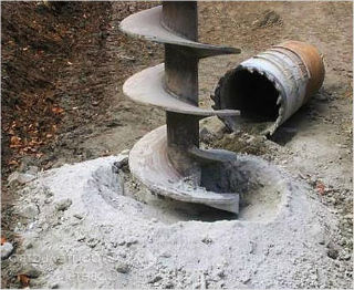
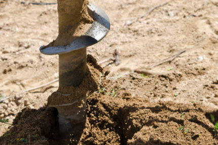
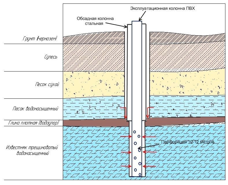
Another advantage of the wells is their simplicity of construction and extreme reliability. The well itself is a channel in the ground, which is created with the help of a drilling rig.
The channel is rather small. To strengthen the walls, obstacles to possible collapses into the well bore, the casing is immersed. At the bottom of the pipe, a filter is mounted, which filters out coarse sand particles.
If we are considering the structure of an artesian well, casing there are different diameters. For example, in the first drilling section, the pipe will have a diameter of 200 mm, and at the last, this figure will already be equal to 120 mm.
For artesian wells, this technology is absolutely necessary, since with a serious deepening the walls of the channels are subjected to enormous loads.
But from the artesian well you get the ideal water quality. As a rule, drilling this type of well always gives the owner access to clean drinking water. Which will be much more useful than the one that was extracted from a regular source and cleaned several times.
And all due to the fact that the depth of the artesian well gives it access to water, which is located in limestone aquifers, where the number of microbes is minimal.
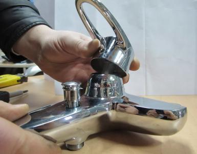
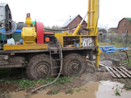
Drilling a well can be done on its own, but the process is quite complex, and it will take you quite a lot of time. Workers with special equipment will be able to drill much faster and better.
To prevent possible freezing of the pipe, pump or the upper part of the well, a special caisson is mounted. This is a small concrete or metal housing, 1-2 meters deep into the ground.
This is where all the equipment of the well, pump, etc. is located. From the caisson the pipe stretches directly to water supply system at home.
In the house, as a rule, water comes through the basement, where it is recommended to install water treatment systems or filters, as they are called in the people. The fact is that the quality of water from wells does not always make it drinkable.
Moreover, in some places, even really deep wells can produce hard or metal saturated with water. Therefore, water treatment will be absolutely necessary in 85% of cases. Another thing is that the degree of water treatment, the number of filters and the way they are placed will be seriously different.
1.1 Selection of the location of the well
First of all, it is necessary to determine the place where drilling will be carried out. Different conditions are chosen for different wells. But there are several basic principles.
To determine the best place to apply a thorough analysis. For example, the order of prospecting drilling, geological analysis of soil, etc. Such actions will give you a 100% result.
If you have friendly neighbors, then you can ask them. Typically, if the neighbors, for example, have a well with a depth of the water mirror at a level of 8 meters, then at about the same mark, the water will be at your place.
Aquifers are most often located very widely. Therefore, the chance that you are on its edge is very small. So after a thorough consultation you can start drilling a well.
In the end, you can turn to people's seekers. But no one will give you a guarantee for their work. And finding a location for a successful location of wells is not a joke.
You can also contact local authorities, services geological control etc. They certainly have if not new, at least not too old maps of the terrain and soil sections.
As for the characteristics of wells, there are only a few. Consider:
- Depth;
- Diameter;
- Type of soil;
- Water quality;
- Performance.
The depth of the wells is strictly individual. It rarely affects the quality of the fluid, although, a certain dependence is traced. The diameter of the wells is 110-250 mm.
Soil type is determined separately with the help of specialists, and this parameter influences the way of well development.
The quality of water is its original composition. It affects how many filters you have to install in order to bring it to a drinking state. Well and it is productive or the debit is an amount of a liquid that the source can give for unit of time.
In sand wells, this figure is 50-80 liters per minute. In artesian it is much higher. The well itself should be strong, reliable, durable. It should give a sufficient amount of liquid and of acceptable quality. It is important to cassette it well, put filters on the bottom and properly maintain it.
2 Technology of well construction for drinking water
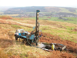
Direct drilling of wells can be trusted by specialists. Moreover, it is very desirable, since it is difficult to handle this work independently. You will have to use improvised means, spend a huge amount of time, energy and energy.
Wells are drilled in several ways:
- Screw;
- Colonial;
- Rotary.
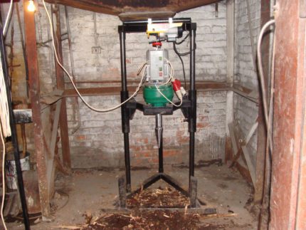
The first two ways can really be applied using a conventional tripod and a special tool. However, screw augers are usually equipped with electronic motors, as their performance in this performance is increased several times.
2.1 method of drilling a well for water (video)
In the absence of central water supply, the most correct option would be drilling water well. Where in the site to drill, when is it better to drill a well? All these questions are very important and the proper operation of the future source of water depends on the correctness of the answer to them. Determining independently the optimal place is not so difficult, if you have the necessary knowledge and take into account the features of the site.
When choosing the location for drilling, many factors are taken into account: the geological features of the site, its relief, the effect of hydrological factors, and the location of the remaining objects of economic activity. In addition, the convenience of locating the future source of water supply is of great importance, which will make it possible to further exploit it without problems.
The selected well site should meet the following requirements:
- the presence of an aquifer;
- convenient location for water intake;
- possibility of water supply;
- providing access to the drilling machine and other equipment for well servicing;
- compliance with sanitary norms;
- absence of power line lines, underground communications.
Also, at the stage of choosing the location for the well, it is worth considering how the pumping equipment will be connected, i.e. take into account the availability of power lines. If in the future you plan a gasket surface water supply from the well, it is desirable that the slope of the site does not exceed 35 °.
When choosing a location for a well, not only the characteristics of its own site are taken into account, but also the adjacent territories for compliance with the specified requirements
Sanitary norms and regulations
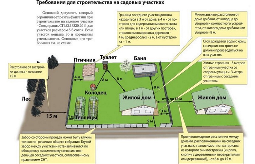
Sanitary standards for the location of water-bearing wells are described in the documents of SanPiN No. 2.1.4.110-02. Undoubtedly, above all, this document concerns large water intakes providing water to populated areas or individual enterprises and districts. However, when installing a private well in your own site, it is recommended that health standards.
In accordance with SanPin regulations, the minimum distance from the source of water intake to residential buildings is 30 m for protected groundwater, and 50 m for unprotected groundwater. It is clear that in conditions of private construction it is impossible to observe these norms. Therefore, it is worth paying attention to the following rules:
- Directly near the well at a site size of at least 4x4 m there should be no residential and economic buildings.
- In a radius of at least 300 m should not be located industrial enterprises, large roads, landfills, cattle graveyards, cemeteries.
- In a radius of at least 20 m there should not be garden crops, watering which is carried out using chemical fertilizers.
- The well should be as far from the cesspools as possible, sewer septic tanks, biotulet and other drainage structures. This applies not only to objects located on your site, but also to neighbors.
It is practically impossible to ensure full compliance even with these norms, so if the water from the well is used not only for irrigation, but also for drinking needs, care must be taken to clean it. The output in this situation may be drilling more deep well artesian type.
The correct choice of the location of the well allows the use of water from the well without the installation of expensive filtration and disinfection equipment
Choosing a place to drill a water source
When choosing a location for drilling a well, the presence of aquifers is crucial. It is from the depth of their occurrence that many factors will depend: the amount of work, the method of drilling, the need for cementing and filtering, etc. Let us consider in more detail which types of groundwater can serve as a source of water for economic needs and how to determine their depth of occurrence.
Image Gallery
Consider four types of groundwater that can become a source of water in your area:
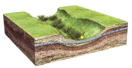
- Verkhovodka - the upper aquifer layer, lying at a depth of 3-4 m. Filled with melted and rainwater, therefore, is highly contaminated. Use such water for drinking and drinking of domestic animals is prohibited, you can use this water to water plants. During the drought and winter, the perch may simply disappear, so the drilling of the well is never carried out before.
- Ground water at a depth of no more than 10 m. Such an aquifer is formed due to the fact that below it are hydro-resistant soils that do not allow seepage downward. Groundwater does not dry out even during a drought. The quality of such waters is quite high, in the presence of filtration systems and observance of sanitary standards, in most cases they can be used for drinking.
- Interplastic non-pressure water. They lie at a depth of 10 to 110 m between two water-resistant layers. Layers can have different structure and water permeability, for example, from above can be sandy loam, and from below - loam. Water quality - usually high, depends on the specific characteristics of the site. Wells that open interplastic waters are most often found on private farms.
- Artesian waters. Located at a depth below 100-110 m. Despite the fact that the water from the artesian well is clean and suitable for drinking, drilling such a well - difficult process, which is not solved by each site owner.
The matter is that for the arrangement of an artesian well it is necessary to agree with the authorities and compliance with the current legislation, including the Federal Law "On Subsoil".
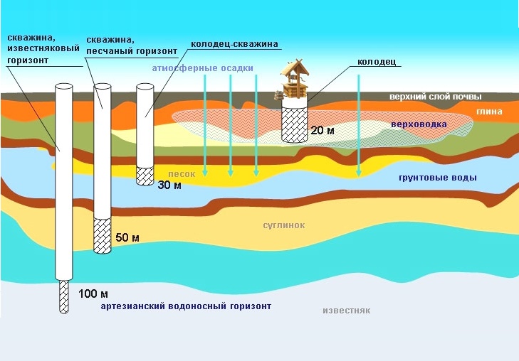
Wells drilled "on sand" and on "limestone", so it is called on geological slang. The most watery and stable is the horizon, confined to cracks in limestone
Visual methods of searching for groundwater
All methods used by experts to determine the depth of the aquifer are based on accumulated experience and centuries-old observations, as well as on the properties that groundwaters have and their impact on the environment. The best option, when the methods described below are used in a complex way, because despite the high reliability, none of the methods does not give a 100% guarantee.
Vegetation on the plot as an indicator
Determine the level of occurrence of perchage on your site will help to study vegetation of natural origin. Pay attention to those plants, which even in the driest period remain green and juicy. The approximate value of the depth of occurrence of groundwater by plant species:
- cattails and reeds, sedge - 1-3 m;
- black poplar - 1-3 m;
- wormwood - 3-6 m;
- alfalfa - 10-15 m.
The shallow occurrence of the aquifer is indicated by trees such as: cedar, willow, alder, birch. But the presence of a pine on the plot opposite, says that the underground waters lie deep enough. If the well is drilled for economic purposes, then a site with similar vegetation is quite suitable.
Note that annuals are not indicative of the depth of the aquifer. they have a short root system and receive the necessary moisture from natural precipitation, dew or perch.
The terrain in the area of the site
In most cases, the aquifer repeats the terrain topography. That is why the best place to drill is to choose the drop zone, because there the water will be closest to the surface. Also, the presence of an aquifer is indicated by longitudinal changes in the area, but it is rather difficult to notice them with an inexperienced look.
Drilling in the lowland is preferable, since the depth of drilling, and hence the financial costs of the construction of the aquifer
In spite of the fact that the lowlands for drilling are preferable, it is impossible to drill a borehole in wetlands, in view of the fact that very poor quality water will enter the well from the surface, while constantly flooding the pit.
Also, the choice of the location of the well depends on the characteristics of the soil: it is desirable to drill in the place where the soils are best suited for development. In this case, sands, loam and sandy loam are much preferable to rock.
Influence of the nearest reservoirs
If within a radius of 300-500 m from your site is located natural reservoir (lake or river), then with a high degree of probability, the aquifer will be located anywhere in the site. In this case, the rule applies: the closer to the natural water body, the higher and more abundant the aquifer will be.
Considering the remoteness of the site from the natural reservoir, do not forget to take into account such a factor as draining sewage or industrial waste into it. In this case, the presence of a nearby lake or river will be more likely to be a negative phenomenon than a positive one.
This is especially true for sandy soils that have high filtration rates, and if mechanical impurities on the way to your site are likely to be filtered out, then harmful chemicals are likely to fall into groundwater, and from there to the well.
Clay rocks have low filtration characteristics, so the choice of a location for a well near natural sources with pollution is unacceptable. In the presence of a clean natural reservoir, a well device on a layer of sand lying between clay soils is possible.
If there is a negative influence on the nearby natural source of water, the device of a shallow borehole is inappropriate, in this case it is necessary to drill to artesian waters
People's Signs and Observations
There are people's signs that our ancestors used during the search for underground water. These signs include the abundance of morning dew in a certain area, as well as the accumulation of evening hazy haze. Such phenomena are very likely to indicate that the groundwater is located close to the surface of the earth.
Also, the depth of the water can be predicted by studying the behavior of domestic animals in hot weather. Dogs do not like to lie where an aquifer layer comes close to the surface of the earth, but cats on the contrary choose such places for their pastime. A small depth of water attracts insects, they swarm over such a place during and after sunset. But rodents and ants to stay away from such places, preferring drier soils.
Of course, it is not worthwhile to completely rely on people's signs, but taking them in conjunction with other signs will not be superfluous. Using folk hints, you can determine the location for the device abyssinian well.
Empirical methods of searching for groundwater
These methods include different ways, which have proven themselves in the search for groundwater in areas different types. To implement these methods, special equipment, measurements and analysis of the information obtained are required. Despite the high accuracy, these methods also do not give a 100% guarantee, but in combination with visual signs they can be reliably considered reliable.
Empirical methods of searching for an aquifer and determining the location of a future well are usually based on initial visual observations
Clay pot: grandfather's way
An ancient method, which our ancestors used to search for underground water. Principle of operation of this method consists in the following: a dry clay pot is taken and set for the day in the proposed location of the aquifer. If after a day the pot was fogging inside, and its walls became wet, it was concluded that the water is close to the surface of the earth.
This method can be used in dry, warm weather. To obtain more accurate results, it is recommended to use several clay pots, comparing their condition after the day, which pot is most wet inside, in that place and the depth of the aquifer is less.
Use of silica gel: a modern method
Silicogel is a synthetic polymeric substance capable of absorbing moisture from the environment. Before use, the substance is thoroughly dried, if kept in the open state. The silica gel is placed in a bag made of natural fabric and weighed, it is enough to take 100-300 gr.
After that, a bag (or several bags) is buried at the points where the aquifer is supposed to be located at a depth of 0.8-1 m. A day later, the bags of silica gel are scooped out and weighed. In the place where water saturates most, silica gel will absorb the greatest amount of moisture, which will affect its weight, it will increase by 1.5-3 times. The greater the increase in weight, the closer to the surface is the aquifer.
Instead of silicogel, you can use any desiccant, for example, pre-crushed and dried clay brick.

Silica gel is part of the filler for the toilet of domestic animals, so to search for groundwater, you can use a regular polymer filler from the pet store
Geophysical method: electrical sounding
To perform a search for groundwater, this method requires special equipment. It is impossible to make a search independently in this case, we will have to turn to professionals, however, this method very high. The principle of operation is as follows:
- in different points of the plot, soil resistivity measurements are made;
- as a result of studies, the aquifer is determined.
Underground waters are fixed in the place where the readings of the instruments are from 50 to 200 ohms. The method is not suitable for the presence of underground utilities, metal structures, the devices will give unreliable results.
The method of biolocation: the search for a frame
The most famous and at the same time controversial way. Some experts consider it effective and scientifically sound, while others call charlatanism. Nevertheless, many cases have been documented, when groundwater was found using biolocation. To implement this method, it is necessary to prepare frames of aluminum wire with a length of 50 cm. The ends of the wire are bent at right angles. The frame is inserted into the branches of the viburnum, hazel or elderberry.
- With the aid of the compass, the sides of the world are determined and we mark them on the site.
- Slowly cross the section from north to south, and then from east to west, holding a biolocation frame in hand.
- In the place of occurrence of the aquifer, the frames begin to move.
- Moving in different directions and following the movement of the frame, we determine the direction of the water-bearing vein.
The use of the frame is based on the action of magnetic fields, so this method is not suitable if the ground of the site contains a large amount of iron ore or nearby there are radar towers that distort the data of the frame-frame.
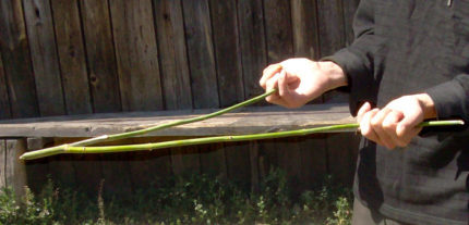
Instead of an aluminum frame, vine branches can be used that are highly sensitive to fluctuations in magnetic fields in the presence of an aquifer
All the methods considered above are widely used for the search for an aquifer and the location of the definition of drilling a shallow well or an Abyssinian well. However, as has already been said, not one of them provides no guarantee that by starting drilling, you will meet groundwater at the expected depth. Is there a way to determine the groundwater level in a particular location? Is it possible to accurately determine the depth of the aquifer? Yes, if you use the method of prospecting drilling.
Exploratory drilling: a reliable method
The most reliable way to avoid annoying miscalculations is to find official information about the hydrogeological situation of the site. Data can be obtained from a local drilling organization or a meteorological service that has all the characteristics of the geological and climatic characteristics of the region.
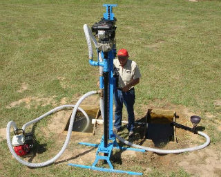
For self-exploration, you can use a manual method that does not require financial costs. Before the beginning of drilling operations it is necessary to prepare the required inventory: hand drill, shovel, as well as take care of the place of storage of the ground raised on the surface.
This method is suitable for soft soils that can be drilled with the help of hand drill. For denser rocks, it will be necessary to call specialists and apply more serious equipment.
Advantages of reconnaissance drilling:
- 100% result of the search and determination of the depth of groundwater;
- possibility to make an assessment of groundwater;
- opportunity to implement accurate calculation cost of drilling.
The exploratory well, as a rule, is not operated and is subject to backfilling.
In the process of exploratory drilling, the depth of occurrence of groundwater, the thickness of the aquifer and the presence of overlapping horizons
Unsuitable places for a well
The main condition for the arrangement of the well in the section is the presence of an aquifer. However, even if it is observed in some cases, drilling of the well is impossible. Signs of unfitness for the location of the well are:
- presence of groundwater pollution in the immediate vicinity;
- place next to the sewer system and wastewater;
- location near ecologically unfriendly natural reservoirs;
- close proximity of power lines and laying along a section of underground communications;
- trees with a branched root system.
Particular attention should be paid to compliance with sanitary standards, in case of their violation, drilling of the well can not be performed. Also, you should not have a well near the fence of the neighbor area, because you can not predict what a neighbor will build on your land in the immediate vicinity of your water source.
Many homeowners consider placing a well in the basement of the house an ideal option.
Image Gallery
Indeed, if the aquifer layer passes just in the area where the house is located or will be built, then this option will have many advantages:
- considerable simplification and reduction of the cost of the process for the installation of a water pipe from the well;
- the shortest waterway route;
- no need for insulation and in the construction of the caisson.
If you want to arrange a water intake within the house, you need to drill a well on the construction site before the foundation is erected. Optimum - to reflect in the project of the house the presence of a water-bearing well in the basement.
The well can not be located under the living rooms, kitchen and bathrooms, the best place will be a basement under a closed veranda, pantry, boiler room
Disadvantages of the location of the aquifer in the basement:
- sufficient space is required;
- difficulties with installation pumping equipment due to the inaccessibility of the well;
- problems in the washing process with discharge of sewage;
- the possibility of erosion of the soil around the source of water and the threat of subsidence in the foundation of the house.
Between the end of drilling and the beginning of the erection of the foundation must be at least 1 month. This period is necessary to identify and eliminate all problems associated with the operation of the well. Note that there should be enough space around the well for maintenance or repair. The minimum size of the site for maintenance is 3x4 meters.
When to drill a well?
Having decided the question of where it is best to drill a water-bearing well, it is necessary to determine when to drill. Experts believe that each time of year has its pros and cons to conduct drilling operations.
Image Gallery
In one they agree unanimously: you can not drill a well in the spring. There are several reasons for this:
- the presence of high water raises the level of groundwater;
- it is impossible to reliably determine the location and depth of the aquifer;
- the spring mudslide will complicate the passage of drilling equipment.
In most regions of Russia drilling is impossible from March to May, in the northern regions from April to mid-June. In dry regions, it is also not recommended to drill in spring, even in the absence of flood, in this case groundwater is still unstable, their level is markedly increased.
Drilling a well in the spring is possible if exploratory drilling was carried out in the summer-autumn period and the depth of the aquifer is well known
Summer-autumn period
The best time to build a well is July-September. At this time, the level of the perch is at a minimum mark, and hence it is possible to accurately determine the optimal horizon for the future well. Also, the advantages of conducting drilling operations in the summer-autumn period include:
- dryness and stability of soil;
- access to special equipment;
- comfortable temperature for drilling operations.
Many site owners prefer to start work on the arrangement of wells in autumn after harvesting, so that the special machinery does not damage the planting, and when flushing the well, there is no contamination of the crops.
When planning the well for the period August-early September, note that at this time the drilling companies are busy, so it is necessary to agree on the date in advance.
Drilling in winter
Winter is an ideal time to drill artesian and sand wells to groundwater. In this case, the risk of an error in the abnormal determination of the aquifer is minimized; The perch water does not interfere with the determination of groundwater level. Modern technology easily copes with frozen ground, while at the minimum harms the terrain of your site.
It is not necessary to rinse the well, most of the impurities will be washed in the spring during the flood. An important factor: during the winter period, the number of customers from drillers is reduced, and hence the cost of drilling operations is reduced.
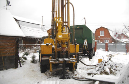
In the winter, special equipment does not spoil the landscape of the site, it does not harm lawns and greenery, the soil left after drilling, will shrink and the harvesting work in spring will be minimized
Video about the choice of location for the well
The choice of the location of drilling a water-bearing well in the area:
The video about self-exploration by a primitive method of drilling:
The choice of the right location for the arrangement of the well is an important measure on which the future fate of the water supply system of your site and home depends. Carefully weigh all the pros and cons of the chosen place, try to take into account as much as possible and predict all the factors that can affect the quality and availability of groundwater.
The main problem of country houses is the lack of constant water supply. Therefore, about 95% of all summer residents face the issue of borehole drilling. Depth of the well depends on the depth of the drinking water floor ground
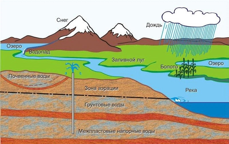
General information about groundwater
Under the ground, there are many aquifers, but not all of them are suitable for drinking or agricultural needs. In most cases, the first aquifer stream is located at a depth of 4-6 meters. Suppose you successfully drilled a hole, and found water, but how to determine its quality? It's very simple - you need to give water for examination. If it turns out that the extracted product is not suitable as drinking water, then it will have to drill even deeper.
At a depth of 15-25 m you will find quite suitable water for personal use and household needs. Crystal clear water is at a depth of 30-60 m.
How to choose a site for drilling a well
There are several factors affecting the depth of the well. For example, the water-bearing vein on the plain is located evenly throughout the territory. The optimal depth of the drilling in this case is 5-15 m. The situation with the hilly terrain is different - here the water can be either under the surface or at a considerable depth of 50-100 meters or more. Remember, the plain or hollow is the optimal zone for finding water.
How to measure the well?
Distance to the top can be determined by an ordinary cable with weighting at the end. Release the cable until the sinker hits the bottom. Hold the cable in the palm of your hand where it stopped, and pull it to the surface. Lay the cable on the ground in a flat line and measure the tape measure.
Addressing specialists can save you time and money, as drilling 1 meter today costs 400-600 rubles. But what if you do not have access to a surveyor? In this case, we recommend that you memorize simple rules that will help determine the aquifer:
- Pre-drilling is one of the best ways to determine the aquifer. You will need an ordinary drill with a length of up to 10 meters and a blade diameter of 15-20 centimeters. The depth of the test hole should not exceed 7-10 m, this is sufficient to determine the presence or absence of an aquifer;
- The aquifer consists of fine sand. Above and below it is covered with a thick layer of clay and limestone. There were cases when a relatively small vein was under a 4-6 meter layer of clay. Therefore, if you stumble upon clay, then you need to continue;
- Use the barometer. The depth of the well for drinking water is measured in two steps: the first measurements are made near a nearby stream or river, and the second - in the place where the construction of the well is planned. Suppose a barometer near the river showed 548 mm, and on your site 547.5, then the water in this place should be at a distance of 5 meters from the surface. The formula for calculation: 548-547,5 = 0,5; 0,5 * 10 = 5 meters.
Types of wells
Drilling a hole is necessary for a certain type of well.
- well for sand (built manually and mechanically) - 7-11 m;
- on gravel: 12-18 m;
- on limestone: 15-35 m;
- abyssinian well: 30-50 m;
- artesian well: 50-80 m.
 Well with quality water For wells located on the sands, it makes no sense to drill too deep holes. Water in such soil is usually located in the area of 5-15 meters from the surface. How deep should a well be drilled in a hilly area? The water-bearing layer for such types is located at a depth of 5-35 m. Sometimes drinking water is also found at a distance of 3-5 meters from the surface.
 What should be a well for gravel? Experienced experts believe that drinking water is located at 12-18 m from the surface. On what water can you count? Gravel is a natural filter, so you can count on drinking water of high enough quality without sand and harmful impurities.
Note that from time to time the water produced can be saturated with sand and other particles. Undesirable impurities say one thing: you need to abandon the exploitation of a spoiled source and start drilling in another place a new one.
A bit cleaner is a well on limestone. It gives a product of excellent quality without sand and metal impurities. The water extracted from the limestone well is several times higher than the types described above. However, to obtain a natural resource in this way, you will need a special permit from the local authorities (the law prohibits unauthorized extraction of resources from the bowels at its site from a depth of more than 5 m).
What should be the depth to get a quality product from an Abyssinian well? A distinctive feature of the Abyssinian hole is that the water in it is located no lower than 30 meters, moreover, the hole itself can go further by 10-20 or more meters.
Artesian wells are a source of crystal clean water. This type is built only for industrial purposes. What kind of water is extracted from artesian wells? From the pit more than 50 m to the surface comes a purified liquid with a unique mineral composition. What is the benefit of such water? It is used for medicinal purposes, for the restoration of intestinal microflora, etc.
Legislative norms for drilling earth's subsoil
Before you make a hole in the earth's crust, you should definitely familiarize yourself with the legal norms. The owner of a land plot is legally the absolute master on his land, however, this does not mean that he can conduct activities that harm the environment or neighbors. The permitted sizes of the well do not exceed 5 m.
However, as they say, in each rule there is an exception. For example, you can get a drilling license for more than 5 m, paying a certain amount for it. If you plan to produce water on an industrial scale, then you need to consult with local authorities to help determine how the optimal depth is allowed within the private sector.
Send an application for the best price in Russia.
Fill out the form below and you will be called back by the manager and will advise you on any questions and will select the best price in Russia.
Whatever is said, but to get your own source of drinking water in the suburban area - this is the ideal option, which everyone dreams about. Moreover, if you try a little, then the source can be obtained without any problems, given that it, as a rule, is and for this you will need drilling.
There is only a very clear question, and how deep the layer is, to provide sufficient pressure at the top. Without resolving this issue, it is not recommended to start work.
Depth: how important
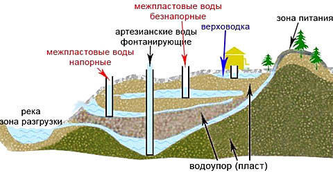
But first it is required to determine in general what types of layers exist.
There are actually four of them:
- 1 - perchage is the highest and simplest, placed at a depth of 4 meters; it feeds on atmospheric precipitation, so it is very dirty or in summer it is not completely dried out;
- 2 - groundwater - such lie up to 10 meters in clay or rocky rocks as waterproof; this source is much cleaner than vadose;
- 3 - interplastic water - from 10 to 100 meters; this horizon is often located between water-resistant clays - the upper layer can be partly permeable, which ensures that the formation is fed from the ground;
- 4 - artesian water - more than 100 m (although sometimes they are encountered and already at 40 m); The source here is the cleanest, although sometimes with impurities.
Helpful advice!
We advise very precisely to understand the terminology of the subject under discussion.
So, often the first two layers, viper and ground, are very similar to each other and they are united under one name "ground".
The first three layers are also called sandy, by the nature of the aquifers.
And the fourth, for the same reason - limestone.
Therefore, they say, "drilling on sand" and "drilling on limestone."
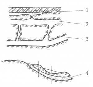
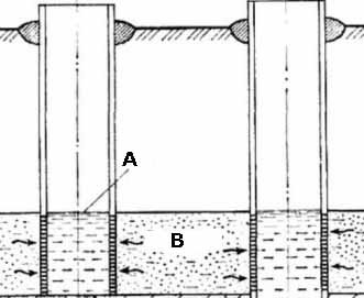
In fact, the situation with underground soils can be much more complicated. The most typical is shown in figure "A".
Here:
- A - surface layer of soils;
- B - groundwater, note the actual position of the formation, the height of which can change at different points of drilling;
- C - water-resistant clays of the upper horizons;
- D - layer of sand and gravel;
- E - rocky bedrock, as waterproof for the lower layers;
- F - deep water;
- G - crack, which can cause loss of the layer.
Determination of depth
The depth of the well for drinking water can be determined in several ways.
The first is the simplest
The simplest, but rather accurate way is this worldly:
- you find a well working nearby;
- learn its depth;
- accurately determine that your aquifer is the same;
- its level of occurrence will be yours;
- for more accurate data, it would be nice to find another pair of wells of the same horizon in order to determine the character of the horizontality of the layer;
- if others approximately have the same index of depth as the first one, then you can with a high probability also include your own to the same.
The second is for the reservoir
But with a simple way can not always be lucky.
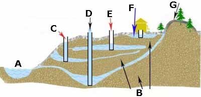
Then it is necessary to be guided by levels of occurrence of layers (figure "B"):
- A - the river, as a zone of unloading water layers;
- B - waterproof layers;
- C - interplastic water, pressure; The well for extraction from here is no more than 50 m;
- D - flowing artesian waters; as a rule - about 100 m, but if you are lucky, you can get a fountain from 40-50 m;
- E - interplastic, non-pressure - from 10 to 30 m;
- F - vagrancy - from 3-4 to 10 meters;
- G is the so-called ground feeding zone.
What does this mean
Know the depth of occurrence of its layer is important, primarily for two reasons:
- first, to determine the necessary labor costs;
- and, second, to determine the specifics necessary equipment, which is clearly demonstrated by the drawing "C":
- if the "well on sand" (A), that is, not more than 50 meters, then it will be enough to have pipes of the same diameter of 127 mm, but they will have to equip everything, there is a high probability of excessive contamination;
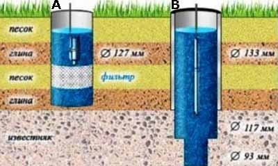
- if the "well on limestone" (B), the occurrence is much deeper, so that a whole cascade of pipes with a gradually decreasing diameter, from 133 to 117 and further down to 95 mm, can not be avoided - a so-called telescopic well is created; although, perhaps, you can manage without a filter.
Helpful advice!
Nominal allowed depth of artesian.
For example, in the Moscow region, they can reach up to 250 meters with a minimum of 35 m. At the same time, one should not be surprised at their popularity, because they have significantly higher productivity due to greater pressure from within. The capacity can reach up to 50 liters per minute, which is enough for 3-5 sites.
conclusions
The instructions and the price depend on the depth of the formation. It is not always possible to determine the depth accurately, but rough estimates do not interfere. Be sure to review the additional video in this article, it will once again allow you to systematize your knowledge of the possible depths of occurrence so necessary for you in the moisture area.
AT country houses and on country plots often there is no possibility to connect to central communications. The need to build a source of water is becoming a major problem. To solve it helps drilling an artesian well. The cleanliness of the water in it and the flow characteristics help to provide the house with a constant source with high output. However, for its erection, a permit is required to drill a well. There are several reasons for the need to collect documentation.
Why is permission required?
Despite the presence of its own site, the resources located in the bowels of the earth are state-owned. Water, which is at a considerable depth, refers to one of these resources. Regulatory issues are clearly spelled out in the federal law.
The main indicator here is the depth of water. If u is located no more than 5 meters from the surface - a resolution is not required. However, if you need to reach sources of drinking water at a considerable depth, you will need to collect a package of documents. Permission to drilling of artesian well is a prerequisite. Without it you can get a big fine. When well drilling depth of about 10 meters fines are lower, but you can force to fall asleep a source of water, which will require additional costs.
What is a permit?
The document is a license issued to a private person for the possibility of drilling a well into the water in the specified zone. Official papers contain:
- information about the owner of the document;
- information on permissible works on the site;
- volumes and types of resources allowed for use (in this case water);
- reasons for preparing documents;
- validity of the permit;
- coordinates of the location of the well;
- geological data about the site of the terrain.
Almost always, along with the main documentation, there are a number of clarifications and permissive conditions, the violation of which will lead to the cancellation of the license. Often the supplement contains requirements for ongoing work, the need to use certain equipment, equipment, and so on.
How to get a license?
Permission to drill a well is issued by the competent state authorities after a set of measures, among which:
- creation of design estimates and geological studies;
- evaluation of all documents drawn up by experts;
- a study of the territory for the availability of resources;
- drawing up a report on the groundwater reserve.
When the volume of water used per day is less than 100 cubic meters, the issue is coordinated with local authorities. Here it is not required expert training report.
If water is used for domestic purposes, it will also be necessary to develop zones health protection. This will help to eliminate the risk of water contamination from external factors (debris, toxins and other harmful substances).
Exceptions to the rules and information on penalties
There are a number of conditions under which the owner may not receive a license to drill a well. In paragraph 18 of the federal law "On Subsoil" it is prescribed:
- The owner of the site can extract water through the well without obtaining permission, in case of its use for personal purposes (for drinking, watering the garden, shower and the like). If there is no financial benefit from the use of water, a permit is not required. However, the transfer of resources to third parties is prohibited.
- The aquifer layer to which the borehole is drilled should not refer to the site of water abstraction by central communication systems or serve as a source of nutrition for organizations.
However, if you need an artesian well, you will need to obtain a license. Without it, citizens or legal entities are subject to sanctions. Penalties for each segment of the population are different:
- to individuals - from 3 to 5 thousand rubles;
- to officials - from 30 to 50 thousand rubles;
- to legal entities - from 800 to 1,000,000 rubles.
Also, if an unregistered source is found, the owner is compelled to eliminate all violations or completely stop the production of water before obtaining an official license.
How to issue documents?
Before drilling an artesian well, it will be necessary to contact the department for subsoil use. This is the competent authority regulating the extraction of water by artesian wells and other types of structures from aquifers located at considerable depths. However, a number of technical parameters are required to obtain a license:
- Install meters to determine the amount of water consumed per day and specialized appliances to monitor the level of groundwater.
- If the amount of water consumed per day is more than 100 cubic meters, it is necessary to drill a monitoring well.
- Inactive wells or structures in disrepair are to be dismantled.
To obtain a license for artesian well, the owner will need to collect a package of documents. Depending on the nature of the owner, the number of documents is different. Individuals will need to bring in the department:
- passport;
- certificate of ownership of land;
- cadastral plan;
- general layout of the territory development;
- plan location of all infrastructure.
The latter must correspond to the reality at the time of application. Collect this package of documents is not difficult. However, if you are a legal entity, you will need:
- a statement issued in a special form;
- contact details of the organization;
- company details;
- certificate of the Unified State Register of Legal Entities;
- information about the leader (for which permission is given);
- certificate of registration of a legal entity;
- form with decoding of activity codes from statistical bodies;
- statutory documents;
- certificate of tax registration.
As mentioned above, for personal purposes, a well is used to draw water from surface soil layers without obtaining a license. However, it is recommended to observe sanitary protection zones and other general requirements at well completion.
Specificity of work performance
If artesian well drilled company , specializing in the creation of water sources for various purposes, it will present a document that indicates the main characteristics of the source of the fence. These include:
- Depth of drilling. This parameter allows you to determine the need to pay money for using the resource.
- Hourly debit. Bandwidth affects many parameters, including the need to use a pump of a certain power. It is necessary to follow the established indicator to ensure a renewable volume.
- Construction and level. The document prescribes the number casing, the type of filter used, and the statistical or dynamic level of the source.
- Location. Each well is entered in the register, therefore it is necessary to specify the exact location of the source of water intake.
- Contractor. Information about the organization that performed the installation of an artesian well is indicated.
When collecting complete information, you receive warranty periods and complete documentation in the event of an inspection by the competent authorities.